skip to main
|
skip to sidebar
Mary Ann Vance - Map Catalog
Sunday, June 29, 2008
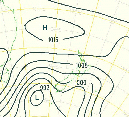
Isobar Map New Zealand
Isoline Maps are maps of continuous lines joining points of equal values; an Isobar represents barometric pressure. This is an isobar map of New Zealand downloaded from
http://www.csulb.edu/~rodrigue/geog140/isobarsnewzealand.gif
.
No comments:
Post a Comment
Newer Post
Older Post
Home
Subscribe to:
Post Comments (Atom)
Blog Archive
▼
2008
(50)
►
July
(32)
▼
June
(15)
Unclassed choropleth map
Statistical Map
Isoyets
Isopleth/Isotachs Map
Isobar Map New Zealand
Flow Map - Migration
Cartogram -GDP of the World
DRG - Blackwater Forest/Hurricane Lake
DOQQ - Navarre Beach, Florida
Remote Sensing-Google Earth Project
Choropleth Map/Proportional Circle Map
Dot Distribution Map/US Census
Propaganda Map
Hypsometric Map
Thematic Map - Capitol
►
May
(3)
About Me
Mary Ann
View my complete profile

No comments:
Post a Comment